Taking action
This page houses a series of articles, reprinted from Open Space magazine. Written by our chairman, Phil Wadey, these articles explore different ways in which we can ensure we take the correct actions needed to preserve unrecorded rights of way.
Our chairman Phil Wadey explains how you can ensure that you will not be losing vital sections of path on the cut-off day, 1 January 2026.
Section 53 of the Countryside and Rights of Way Act 2000 provides that footpaths and bridleways that existed on 1 January 1949 but are not on the definitive map on the cut-off day will be extinguished, subject to safeguards yet to be put in regulations.
The cut-off was to take effect on 1 January 2026 preceded by an intensive quarter century of identifying and applying for routes to be added to the definitive maps.
More than half that time has passed and it is now essential that we carry out research and make applications for unrecorded, or under-recorded, paths to be put on the definitive map of rights of way—or they will be lost for ever.
Three categories of path are particularly vulnerable because they may be wrongly assumed to be correctly recorded and so no one will make an application for their retention.
These are:
- paths shown on the Ordnance Survey map as ‘other routes with public access’ (ORPAs);
- definitive map anomalies; and
- routes straddling local authority boundaries.
ORPAs are shown with green blobs on the OS Explorer maps and red blobs on the Landranger series.
Vulnerable
Examination of ORPAs in Hertfordshire has shown that, although information about these paths was supplied to Ordnance Survey, several are no longer shown on the list of streets (a list of highways maintainable at public expense which, under section 36(6) of the Highways Act 1980, each highway authority has a duty to keep).
The danger is that any route that was a public highway before 1949 and is not on the list of streets or definitive map in 2026 will be extinguished, even if it is the only means of access to a continuing footpath, bridleway or byway.
We recommend that you identify the ORPAs on an OS map sheet and highlight those that do not appear to be ordinary roads. For each of those highlighted, you should check the list of streets to see whether it is recorded. If it is not, you should add the route to your ‘highways under threat’ list for future work.
The second category is the one many authorities refer to as ‘anomalies’. This is where a path suddenly changes status, often at a parish boundary. I include in this category those paths that run along or meander close to a parish boundary, where part of the path falls in a different parish from most of the length.
Stop short
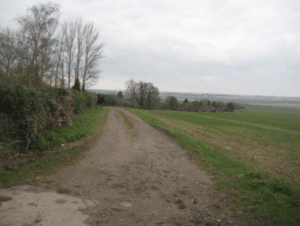
Unrecorded track leaving Wallington 32BW in north Hertfordshire, grid reference TL 2942 3368. This route is at risk. Photo: Phil Wadey
In Hertfordshire I have found examples of paths which stop 10 to 50 yards short of another highway, with the gap neither on the definitive map nor on the list of streets. Others have been found where just a short distance falls in a different parish, and it was not recorded there.
Where these are highways, they are likely to be lost in 2026 and so need adding to the definitive map. Worse still, I have found examples where the council signpost is on the road, so the walker or rider would be unaware that the path was in danger.
The track in the photograph (right) is signposted as ‘bridleway 32’ just to the left of the photographer, yet the definitive map does not show the bridleway starting for another 30 yards.
We recommend that you look carefully for any unexpected changes of status of paths, or gaps between paths and the roads they should be joining, and highlight these as needing investigation.
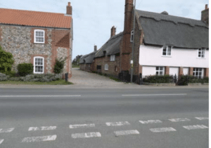
Road near Peter’s Green, Harpenden, Hertfordshire, grid reference TL 1389 1877 Photo: Phil Wadey
The third category of unusual path is the one that straddles a county or unitary authority boundary.
The route in the photograph (left) looks like a normal road. It is maintained, and anyone driving along it would have no idea that on the cut-off day half of it could vanish due to administrative error. The route runs along the county boundary between Hertfordshire and Central Bedfordshire.
In Bedfordshire (the lefthand half) the road is on the list of streets, but in Hertfordshire it is not recorded at all. If there is no application for the route it is likely that only the Bedfordshire strip would retain public rights.
Vehicular rights
When the Natural Environment and Rural Communities Act 2006 extinguished mechanically-propelled vehicle rights that were not recorded, section 67(2)(b) retained the rights on routes shown in the lists of streets.
However, in many places the lists were inaccurate; thus there are now many routes which in law probably no longer have the status needed for driving, even though they look like roads.
These routes could be lost to walkers, riders, cyclists and carriage drivers, and I recommend that you examine all routes that run along the boundary with a neighbouring authority, especially those that lead to routes shown on the definitive map, and then that you check the list of streets in both authority areas to ensure the route will be safeguarded.
For more information about applying to add routes to the definitive map, click here.
In this, the second article of a series about preserving unrecorded rights of way from extinguishment on the cut-off day, 1 January 2026, our chairman Phil Wadey explains how to start a systematic search for routes.
There are of course many ways of starting a comprehensive trawl for unrecorded paths but, with so many possible approaches, those wanting to perform research often just need a single method to get going. As ever when researching, it will be necessary to keep good notes of what is found and to take photographs or copies of any records examined.
I use an old Ordnance Survey Explorer map for noting any routes I find. I number these routes, so that I can refer to them when taking notes about what is seen on the historical documents. If you take good notes at this stage, whether handwritten or on a laptop or tablet, it will save much time later when you are compiling applications to modify the definitive map.
The old road leading to the sea in Bacton, Norfolk. Not currently recorded but found by comparing IR maps with modern highway maps. Photo: Ian Witham
A popular first step is to use the documents produced for the Finance (1909-10) Act 1910. The act required the Inland Revenue (IR) to value all land in the UK. The purpose was to charge a tax on any increase in value when the property was later sold or inherited.
Each property, known as a hereditament, was numbered, had its boundary plotted on Ordnance Survey (OS) county series second-edition maps (known as valuation maps), usually at a scale of 1:2500, and had its details recorded in field books. The IR valuation-map may reveal many useful features for rights-of-way researchers. Where land is left uncoloured, and so is separate from any hereditament and unvalued, this indicates that it was exempt from valuation.
Section 35 of the 1910 act exempted rating authority land from valuation. A highway authority was a rating authority. If a track is unvalued, it is likely to have carried vehicular rights unless some other exemption can be determined. All white roads should be checked against a modern map, and any that do not appear to be modern roads should be added to the research list as candidates for modification-order applications.
The IR valuation-plan information was drawn on a second edition OS county series map. If any of the white roads are named on the map, this should be noted. The OS Object Name Books, held at Kew, will record the name, have a short description of the feature (for example, ‘public road’) and be vouched for by someone in a position to know that the name and spelling were correct. While this may be the vicar or schoolmaster, sometimes it is the surveyor of highways, which is a bonus.
Section 25 of the act gave a discount on the valuation if there were footpaths or bridleways across the land.
The map should be checked firstly to see if any tracks are marked ‘FP’ or ‘BR’ on the underlying OS base map, and secondly to see if the valuation office has noted any footpaths or bridleways—this will be shown in handwritten ink. Some valuation officers noted paths on the map in this way. Make a note for further research of all paths indicated by either method. Record the name as printed of any railways or canals crossing the valuation map.
If any candidate routes cross a railway, there may be useful evidence to be found later from the railway plans and books of reference deposited as part of the process of obtaining a private act of parliament authorising the construction. Such records can be found at the Parliamentary Archives and often also at County Record Offices.
I have examined more than 90 per cent of the 528 individual IR valuation-maps in Hertfordshire, for white roads, named routes and railways and canals. The results are astonishing in that they reveal so many footpaths, bridleways and byways which need recording.
Old road named Drift Way in Sandon, Hertfordshire, is a white road on the IR survey. Photo: Phil Wadey
Following the Natural Environment and Rural Communities Act 2006 (which prevented the claim of many vehicular routes), I have found that more than two thirds of the unrecorded white roads on the IR maps appear to have lost their motor-vehicle rights and so will be restricted byways when recorded.
Candidate paths
As a result of this research, I identified some 250 candidate paths. I have submitted more than 100 of these, with other evidence, to the county council as modification-order applications.
Other counties also have many paths to record. In Norfolk, OSS local correspondent Ian Witham has been following this method of researching IR valuation-maps. His examination of 50 valuation plans has revealed 108 paths for investigation. He has made three applications after adding other evidence. This method can uncover plenty of routes for recording—thus reducing the potential loss on the cut-off day.
For more information about applying to add routes to the definitive map, click here.
In the third of a series about preserving unrecorded rights of way from extinguishment on the cut-off day, 1 January 2026, our chairman Phil Wadey looks at the use of tithe and inclosure records as evidence of highway status.
We saw last time how to be systematic in examining the 1910 Inland Revenue (IR) valuation-maps and related records in order to extract the most information from them. The aim was to look at each document just once (and photograph it) and to record each feature that might or could assist in proving a highway (footpath, bridleway or byway).
The method can be applied to other documents. After the IR documents the next most useful are the records relating to tithes and inclosures. These documents often reveal footpaths and bridleways as well as roads, whereas the IR documents might not show the exact routes of footpaths and bridleways for which tax deductions were claimed.
Tithes
From the ninth century tithes were paid in kind by parishioners and landowners to support the church and the parish priest. The tithe was 10 per cent of the produce of the land (for example, crops, animals and wool). In the nineteenth century, there was a move to make this easier to handle, and the rector or vicar preferred money to goods.
Once the procedures in the Tithe Act 1836 had been followed, all remaining tithe charges were commuted, and the church received money instead.
As part of the process, the land in the parish or tithe district was mapped. Each land parcel was given a number, and the use of the parcel and its acreage are listed in the apportionment document that accompanies the map. Land that was not subject to tithes was generally accepted to be public or owned by the church or crown estate. Such land would not have an apportionment number on it.
Public roads were also exempt from tithes (unless a crop could be taken) and so were often unnumbered. In many cases, highways were coloured in sienna (light brown), but this is not universal.
Apportionment
For our purposes, it is good to check each tithe map for its highways. These are frequently roads but sometimes bridleways. If there is doubt, other evidence will be needed to help determine which they are.
The apportionment should be checked as this will often list the routes as roads so helping to determine status at the time. For each untithed route, check whether it is a public road today, and if not, whether it is shown on the definitive map. Any missing or under-recorded routes should be added to your index of paths under investigation.
Do remember to take photographs of the whole of the tithe map and apportionment once it has been obtained from the archive, so that you need not look at it again. Take close-up photographs of routes that have been added to the index of paths and of any key to the map.
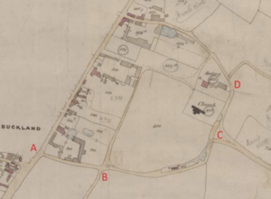
Part of the 1844 tithe map of Buckland, five miles south of Royston in Hertfordshire. The route A-B is today recorded as a footpath. B-C-D is unrecorded. Both have now been applied for at restricted byway status. Supporting evidence included the
route’s depiction on pre-1835 maps
which were sold to the travelling
public, and the fact that it was
unvalued on the IR survey. Photo:
Karin Frapporti.
Inclosures
Inclosure records were compiled when a few landowners grouped together to combine and reallocate lands in order to improve methods of agriculture and their profits. This process reduced the common-grazing areas.
The landowners would apply to parliament for an inclosure act to be passed, after which commissioners were appointed to carry out their survey, prepare map(s), make the distribution or award and set out the new road network and land ownership allocations.
Inclosure affected especially the Midlands, Lincolnshire, the East Riding and Norfolk. The most important point here is that new highways were set out, and some old highways were left in place. As it was a process conducted under an act of parliament, and had to be agreed by the majority of landowners affected, it has high evidential value.
Each inclosure map should be examined for the presence of highways. For each one, check whether it is a public road today, and if not, check whether it is shown on the definitive map. Any missing or under-recorded routes should be added to the index of paths under investigation.
The map alone is not sufficient. It is always necessary to read the award in which the commissioners described what was being set out; this should reveal whether a route on the map was a new highway or an existing one, and whether a new highway was a road or just a bridleway.
The act of parliament that authorised the particular inclosure should also be read in case there are provisions that affect the setting out or retention of highways.
Project work
The nature of these documents lends itself to project work that various people could undertake. Examination of all tithes in a county would be an enormous piece of work for an individual, but if it is shared among a research team, with results sent back to a coordinator, the workload becomes manageable.
Volunteer helpers, once familiar with what is needed, can examine each document, extracting the relevant information for use, with corroborating evidence in definitive map modification order applications.
Further information on locating and interpreting tithe and inclosure documents can be found in Rights of Way: Restoring the Record by Sarah Bucks and Phil Wadey.
In the fourth of a series about preserving unrecorded rights of way from extinguishment on the cut-off day, 1 January 2026, our chairman Phil Wadey looks at routes that call for investigation.
In the last three articles we have considered how to take action in respect of evidence found for rights of way that are unrecorded or under-recorded on the definitive map of rights of way.
However, some people have questioned whether there are any unrecorded rights of way, or have otherwise wanted to know how to find routes that ought to be investigated. Some readers have even suggested that there may be no unrecorded ways in a whole county: in my experience this is most unlikely.
In this article we consider some starting points for research. They will not all produce paths that can be added to the definitive map, but many will. Each case will, as ever, need to be considered on its merits once evidence has been collected.
A good place to start is with an Ordnance Survey Explorer map of the area of interest. Examine this carefully, first paying particular attention to how paths are shown. On most maps, examples will be found of where footpaths change status to bridleway, bridleways change status to restricted byway, or any path seems to stop in the middle of nowhere, all for no clear reason.
Each such change should be highlighted, and subjected to investigation using the evidence sources considered in previous OS articles.
Identify
In one of the articles above we mentioned the need to identify routes shown on the Ordnance Survey as ‘other routes with public access’ (ORPAs). Although the county councils and unitary authorities supplied the information to the Ordnance Survey in the first place, many councils no longer have some of those routes recorded on their definitive maps or in their lists of streets.
Such routes are eligible to be recorded as restricted byways or byways open to all traffic, while others will be ordinary all-purpose roads. Each ORPA shown on a map should be investigated to see if it needs to be recorded.
Highwoodhall Lane, Abbots Langley, Hertfordshire. Spotted as a route with public access but no longer to be found on the county’s list of streets in 2010. Restricted-byway status applied for on 20 September 2010. Photo: Phil Wadey
Other paths deserving investigation include those wide routes that seem to ‘carry on’ when a road goes round a sharp corner, and where much of a Roman road is recorded as a path but there are gaps in the definitive line. Again, these indicators are not evidence in themselves, but investigation often reveals evidence that can lead to a path being recorded.
Crossings
For those interested in investigating crossings, many under-recorded paths can be found by reviewing the status of every railway and motorway crossing.
Many crossings, in addition to those suggested on the OS map, will be found to be used by the public, and such routes will need to be investigated, usually starting by looking at the legal records that created the railway or motorway.
For example, in North Mymms parish, Hertfordshire, two bridleway-standard bridges were found crossing the A1(M) motorway, yet neither was on the definitive map. Although these were not pre-1949 paths (and so would not be caught by the cut-off) they were proven by using documentary evidence.
Further information on locating evidence of rights-of-way status can be found in Rights of Way: Restoring the Record by Sarah Bucks and Phil Wadey.
Our chairman Phil Wadey explains why, in England, it is urgent for applicants for definitive-map changes to challenge councils which have failed to make progress with those applications.
In England the Deregulation Act 2015, which is shortly to come into effect, will trigger the closure of definitive maps to claims based purely on historical evidence, on 1 January 2026. It is therefore vital that we apply for additions where we have evidence.
Continuous review
Under the Wildlife and Countryside Act 1981, since 1983 the definitive maps of rights of way have been under ‘continuous review’. That is, the surveying authority (the county council or unitary authority) makes an order to modify the map one path at a time, instead of the previous system where changes were batched and the whole map was reviewed every so many years.
The council is required adequately to resource the duty to maintain its definitive map so that, for every application made by a member of the public to change the map, there should at least be a decision whether to make an order within 12 months of the applicant certifying that he has told the owners and occupiers of the application.
Very few councils have allocated enough staff to meet the 12-month requirement, although there are a few high achievers. Fortunately, the 1981 act made some provision for this. Under the current law (para 3(2) of schedule 14 to the 1981 act), 12 months after serving the certificate on the council confirming that the application process is complete, it is possible to make an application to the secretary of state (England) or Welsh ministers (Wales) that she or they direct the council to determine the application within a further set period of time.
The process for making a ‘direction application’ is straightforward, by email or letter, as there are no special forms (see the government guidance for England). We recommend that, before seeking a direction, you write to the council to ask why the application has not been determined.
Policy
The secretary of state and Welsh Ministers currently have the same policy for considering requests for directions. They look first at whether the council has a statement of priorities setting out its general way of deciding which applications to consider next, and then at whether that statement is reasonable. They check any actions the council has taken and its expressed intentions to act, including any estimate of when determination will take place. The general circumstances of the case and, importantly, the views of the applicant are also relevant.
Recent decisions can be found here for England and here for Wales although in mid-August there were no directions on the Welsh website.
Of particular interest are the comments made by inspectors on the reasonableness of council policies. For example, Bradford Metropolitan District Council was directed to determine a footpath application last year[1]. The inspector found that the council’s general policy of prioritising was satisfactory, but went on to consider that a delay of nine years since the application had been made, with no prospect of the case starting to be examined for a further eight years, was unacceptable. The council was instructed within 12 months to make a decision whether to make an order.
In 2004 Cornwall Council received the certificate confirming notification of landowners and occupiers of land crossed by an alleged footpath[2]. The council did not expect to reach this case until 2024, some 20 years after the certificate was issued, meaning that some of the witness evidence would be over 40 years old. A direction was issued giving the council 18 months to reach a decision.
This last case raised two additional points. Firstly it was the second attempt to obtain a direction, the first having been unsuccessful in 2009. This shows that the secretary of state can change his or her mind about a direction when there is continued failure to make progress. Secondly, the applicant referred to earlier decisions of the secretary of state in which directions had been granted; the decision letter dismissed these arguments saying that each case is considered on its merits.
Before making an application, it is worth checking the council’s statement of priorities and asking when it thinks the application will be decided. If this is going to be a long time, an application for a direction would be worthwhile, even if there are no other features of the case that would raise its priority. Under the package of reforms in the Deregulation Act 2015 which will be introduced in England later this year, it will no longer be possible to request the secretary of state to give a direction. Instead, applicants must go to the magistrates’ court.
The major drawback of the new approach is the cost: current court fees are £205 to commence proceedings and £515 for a contested hearing; these will deter many. If you are conducting systematic research, we advise you to go to court with a number of applications simultaneously since one fee will cover them all. But for many, the ability to get councils to act more quickly will be lost.
So we urge anyone in England whose application has remained undetermined for more than 12 months to request a direction to determine, and thereby benefit from the pre-deregulation system. Applicants for Welsh paths need not worry for now, though it is probably worth getting on with it.
For an example of two representations on Hampshire applications see here. They may be more detailed than you need, but note the reference to the third reading of the Wildlife and Countryside Bill in the House of Lords on page 2, which sets out the government’s intentions for the provision.
Green Lane, Ilminster, Somerset. The application was made in 2010. The secretary of state has directed that it be determined by 14 July 2017[3]. Photo: Sarah Bucks.
[1]FPS/W4705/14D/2 dated 8 June 15.
[2]FPS/D0840/14D/10 dated 8 June 16.
[3]FPS/G3300/14D/2 dated 14 July 16.
In ‘Highways under threat, Challenging councils who have failed to make progress with definitive map change applications’, our chairman Phil Wadey explained how to complain to the secretary of state if a council is failing to progress your modification-order applications—and why (for England) this action needs to be taken promptly. In this guidance note, he gives a short update on a recent case.
At present, the secretary of state and Welsh ministers have the same policy for considering requests for directions.
Their appointed inspectors look first at whether the council has a statement of priorities setting out its general way of deciding which applications to consider next, and secondly at whether the council’s statement is reasonable.
The inspector considers any actions the council has taken and says it intends to take, including any estimate of when determination will take place. The general circumstances of the case and the views of the applicant are also relevant.
Featherbed Lane
Featherbed Lane. Photo: Phil Wadey
When the M1 motorway was constructed, Featherbed Lane (one mile north of junction 6a) in St Stephen parish, Hertfordshire, was severed. The approaches to the motorway were not stopped up, but no new linking routes were put in place. The application to record the route was made in 1997.
The inspector gave the council one further year to reach a decision on the case (FPS/M1900/14D/2 dated 18 Jan 2017, available at www.gov.uk).
The surveying authority, Hertfordshire County Council, has adopted a statement of priorities for investigating applications to modify the definitive map. The council processes cases of equal priority in the order in which they were received.
Prioritisation
I had admitted that by and large the prioritisation system was OK, but argued that it did not take account of the age of the application (as opposed to the date when it was registered). I suggested adding one point to the prioritisation score for each year of delay so that every application would eventually reach the top of the pile.
While not commenting on this idea, the inspector took the view that, without time as a factor, some applications could wait for ever. The unreasonableness of waiting another 12 years after the near 20 years’ delay was highlighted in the inspector’s consideration.
We recommend you to look at the likely time it will take for the council to reach a decision at its current rate of progress, and emphasise this in your direction application.
Thus, a direction application can succeed even if the authority is making progress with applications. (Hertfordshire determined over 30 cases last year.)